WESTERN BHUTAN
Western Bhutan is comprised of Paro, Thimphu and Punakha, Wangdue Phodrang and Phobjika valleys separated by high passes or "La" - Cheili La (3900m / 12,795ft.), Dochu La (3,050m / 10,007ft.) and Pele La (3,500m / 11483ft.). Western Bhutan is known for its stunning scenery with rice paddies cascading down magnificent mountains, the pristine rivers that flow through the main towns of Paro, Thimphu and Punakha, and unique two-story houses with brightly painted window designs. Below are described the main areas of Western Bhutan.
PARO VALLEY
Altitude: 2,250m / 7,382ft.
A trip to Bhutan normally begins and ends at Paro ..... and there can be few more charming valleys in the kingdom. As you disembark your Druk aircraft and take your first breath of Bhutanese air, you will be struck by the clean air and peaceful atmosphere.
National Museum.
The museum's collection includes ancient Bhutanese arts and artifacts, weapons and stamps, birds and animals, and an incredible collection of silver tea ware. This is typical of the eclectic beauty of Bhutan - its prized objects bear little relation to each other but as a whole stand together as a history of one of the world's most pristine people.
Taksang Monastery
It is said that Guru Rinpoche (Precious Master), the father of the Bhutanese sect of Mahayana Buddhism, arrived in Paro Valley more than a millennium ago on the back of a legendary tigress. He meditated for three months in a cave where a monastery was later built and called Taktsang Lhakang or Tiger's Nest Visitors to Paro can take a closer look at the monastery by ascending either on foot or by pony for about three hours to Tiger's Nest. Walkers can enjoy a rest at the Taktsang Teahouse situated at a wonderful vantage point overlooking the monastery. On clear days you can get a clear view of mount Chomolhari the sacred peak of Bhutan.
THIMPHU VALLEY
Altitude: 2,350m / 7,710ft.
Thimphu is a small, charming capital city sandwiched in the heart of the Himalayas. It sits in its own valley fanning out from the river. The skyline hardly changes as new buildings are all constructed under zoning regulations. Thimphu's development is strictly monitored and buildings cannot exceed a certain height, nor can they be designed in anything but the traditional Bhutanese style. In fact, Thimphu's first and only traffic light was enshrined in a chorten ! (a small Buddhist temple). Not being suitable to the nature of Thimphu, the traffic light was removed on the King's orders.
Only a sprinkling of cars are found along the main street and the capital's population is not immediately visible. But, if you look inside the bank or the shop, you will find Thimphu's people and Bhutan's heart. Dressed in gho or kira (a wrap-around robe), Thimphu people go about their work methodically, quietly bringing their nation through the growing pains of development and into its own definition of the modern world.
Simtokha Dzong, six kms from the city limits, is the kingdoms oldest dzong which is now used as the Dzongka language school of Bhutan. Bhutan's most stately and arguably most impressive building is Tashichhodzong, on the banks of the Wangchu (Thimphu River). The home of the National Assembly and the summer residence of the capital's venerated monastic community, Tashicchodzong is a palatial building overlooking the river on the South side and the city of Thimphu from the North. While foreign visitors are only allowed to enter Tashicchodzong during the annual festival, its presence and its exterior and grounds provide a delightful spectacle. The dzong is the impressive result of a redesign of the original medieval structure sanctioned by the Third King, HM Jigme Dorje Wangchuck, when he moved Bhutan's permanent capital to Thimphu.
From the pass the road curls its way down into the relative lowlands of the Punakha Valley. Before Thimphu was made the permanent capital of Bhutan, Punakha was the Winter Capital because of its more temperate climate. The Je Khenpo (leader of Bhutan's religious order) and his council of monks still come to pass the Winter months here.
Punakha Dzong was strategically built at the confluence of the Pho Chu (male) and Mo Chu (female) rivers by the first Shabdrung of Bhutan, Ngawang Namgyel in 1637. It has been damaged by four fires and an earthquake in 1897 and has been devastated by flood water coming from the great northern glaciers. The Dzong has now been fully restored to its original splendor.
WANGDUEPHODRANG
Altitude: 1,310m / 4,300ft.
Wangduephodrang is the last westerm town on the highway before central Bhutan. Wangduephodrang (or Wangdue) is a typical small Bhutanese town. It has a bustling market with well stocked shops and a pretty view of the valley and dzong.
PHOBJIKA VALLEY AND GANGTEY GOMPA
Altitude: 2,900m / 9,510ft.
A few hours' drive from Wangduephodrang is Phobjika valley. Here also is Gangtey Gompa, a monastery dating back to the 17th century. This short journey south from the main East-West artery is well worth the detour for the dramatic change of scenery. The monastery is inhabited only in summer months.
Spotting black-necked cranes in the meadows of the valley floor is an ornithologist's dream come true. These rare birds migrate from the high plains of the Tibetan plateau in Winter to the milder climate of Phobjika.
PHUENTSHOLING
Altitude: 300m / 985ft.
Popularly known as the 'Gateway to Bhutan', Phuentsholing is a vibrant town located adjacent to the Indian border town of Jalpaiguri, a district of the Indian state of West Bengal. The town is a bustling commercial centre providing a glimse of Indian merchants and Bhutanese dressed in traditional khos and kiras. The climate of Phuentsholing contrasts greatly with the higher land of Bhutan. It is tropical, hot and humid during the summer, and warm and pleasant in the winter. It is located 180 km from Thimphu and is about a six hours drive. Phuentsholing is the only other entry/exit point to Bhutan other than the airport at Paro. The closest Indian domestic airport is at Bagdogra, about 160 km from the Bhutanese boarder, which is connected by daily flights to Delhi and Calcutta.
Western Bhutan is comprised of Paro, Thimphu and Punakha, Wangdue Phodrang and Phobjika valleys separated by high passes or "La" - Cheili La (3900m / 12,795ft.), Dochu La (3,050m / 10,007ft.) and Pele La (3,500m / 11483ft.). Western Bhutan is known for its stunning scenery with rice paddies cascading down magnificent mountains, the pristine rivers that flow through the main towns of Paro, Thimphu and Punakha, and unique two-story houses with brightly painted window designs. Below are described the main areas of Western Bhutan.
PARO VALLEY
Altitude: 2,250m / 7,382ft.
A trip to Bhutan normally begins and ends at Paro ..... and there can be few more charming valleys in the kingdom. As you disembark your Druk aircraft and take your first breath of Bhutanese air, you will be struck by the clean air and peaceful atmosphere.
National Museum.
The museum's collection includes ancient Bhutanese arts and artifacts, weapons and stamps, birds and animals, and an incredible collection of silver tea ware. This is typical of the eclectic beauty of Bhutan - its prized objects bear little relation to each other but as a whole stand together as a history of one of the world's most pristine people.
Taksang Monastery
It is said that Guru Rinpoche (Precious Master), the father of the Bhutanese sect of Mahayana Buddhism, arrived in Paro Valley more than a millennium ago on the back of a legendary tigress. He meditated for three months in a cave where a monastery was later built and called Taktsang Lhakang or Tiger's Nest Visitors to Paro can take a closer look at the monastery by ascending either on foot or by pony for about three hours to Tiger's Nest. Walkers can enjoy a rest at the Taktsang Teahouse situated at a wonderful vantage point overlooking the monastery. On clear days you can get a clear view of mount Chomolhari the sacred peak of Bhutan.
THIMPHU VALLEY
Altitude: 2,350m / 7,710ft.
Thimphu is a small, charming capital city sandwiched in the heart of the Himalayas. It sits in its own valley fanning out from the river. The skyline hardly changes as new buildings are all constructed under zoning regulations. Thimphu's development is strictly monitored and buildings cannot exceed a certain height, nor can they be designed in anything but the traditional Bhutanese style. In fact, Thimphu's first and only traffic light was enshrined in a chorten ! (a small Buddhist temple). Not being suitable to the nature of Thimphu, the traffic light was removed on the King's orders.
Only a sprinkling of cars are found along the main street and the capital's population is not immediately visible. But, if you look inside the bank or the shop, you will find Thimphu's people and Bhutan's heart. Dressed in gho or kira (a wrap-around robe), Thimphu people go about their work methodically, quietly bringing their nation through the growing pains of development and into its own definition of the modern world.
Simtokha Dzong, six kms from the city limits, is the kingdoms oldest dzong which is now used as the Dzongka language school of Bhutan. Bhutan's most stately and arguably most impressive building is Tashichhodzong, on the banks of the Wangchu (Thimphu River). The home of the National Assembly and the summer residence of the capital's venerated monastic community, Tashicchodzong is a palatial building overlooking the river on the South side and the city of Thimphu from the North. While foreign visitors are only allowed to enter Tashicchodzong during the annual festival, its presence and its exterior and grounds provide a delightful spectacle. The dzong is the impressive result of a redesign of the original medieval structure sanctioned by the Third King, HM Jigme Dorje Wangchuck, when he moved Bhutan's permanent capital to Thimphu.
One of the most enjoyable ways of passing time in Thimphu is wandering through the town. Full of wonderful restaurants and delighful shops stocked with items from all over Bhutan. Hand woven textiles, woodcarving, tailor made clothing, jewelry. Thimphu's weekend market is another chance to watch the way life in the kingdom. Here, every weekend, Thimphu's residents break from whatever it is that they are doing to stock vegetables, a copy of Kuensel (the weekly newspaper) and to exchange the week's gossip. For visitors who can't share in the gossip, a wander through the stalls reveals mountains of bright red chilies, eggplants and okra, asparagus in season and rice of many types. Traditional Bhutanese masks, incense, hand made knives, jewelery are also sold here. It's an incredible experience for the visitor.
Another of Bhutan's loveliest exports is its wide and diverse collection of stamps. These are best seen in commemorative books at Thimphu's central post office. Other places of interest in Thimphu include the traditional painting school where the age-old styles of Bhutanese painting, including thangka painting, are taught and the Memorial Chorten build in memory of His Majesty, the Third King of Bhutan. The National Library houses a vast collection of books and research documents of Buddhist studies.
PUNAKHA VALLEY
Altitude: 1,310m / 4,300ft.
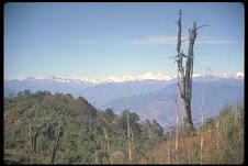
The first stop after leaving Thimphu on the journey east is Dochu La (la means pass) at 10.007ft. Only an hour's drive from Thimphu, it offers visitors their first glimpse of the Eastern Himalayan range. The best time to reach Dochu La is early morning when the mountain views are clear and one can enjoy a spectacular panoramic views of the Bhutanese Himalayas.
From the pass the road curls its way down into the relative lowlands of the Punakha Valley. Before Thimphu was made the permanent capital of Bhutan, Punakha was the Winter Capital because of its more temperate climate. The Je Khenpo (leader of Bhutan's religious order) and his council of monks still come to pass the Winter months here.
Punakha Dzong was strategically built at the confluence of the Pho Chu (male) and Mo Chu (female) rivers by the first Shabdrung of Bhutan, Ngawang Namgyel in 1637. It has been damaged by four fires and an earthquake in 1897 and has been devastated by flood water coming from the great northern glaciers. The Dzong has now been fully restored to its original splendor.
WANGDUEPHODRANG
Altitude: 1,310m / 4,300ft.
Wangduephodrang is the last westerm town on the highway before central Bhutan. Wangduephodrang (or Wangdue) is a typical small Bhutanese town. It has a bustling market with well stocked shops and a pretty view of the valley and dzong.
PHOBJIKA VALLEY AND GANGTEY GOMPA
Altitude: 2,900m / 9,510ft.
A few hours' drive from Wangduephodrang is Phobjika valley. Here also is Gangtey Gompa, a monastery dating back to the 17th century. This short journey south from the main East-West artery is well worth the detour for the dramatic change of scenery. The monastery is inhabited only in summer months.
Spotting black-necked cranes in the meadows of the valley floor is an ornithologist's dream come true. These rare birds migrate from the high plains of the Tibetan plateau in Winter to the milder climate of Phobjika.
PHUENTSHOLING
Altitude: 300m / 985ft.
Popularly known as the 'Gateway to Bhutan', Phuentsholing is a vibrant town located adjacent to the Indian border town of Jalpaiguri, a district of the Indian state of West Bengal. The town is a bustling commercial centre providing a glimse of Indian merchants and Bhutanese dressed in traditional khos and kiras. The climate of Phuentsholing contrasts greatly with the higher land of Bhutan. It is tropical, hot and humid during the summer, and warm and pleasant in the winter. It is located 180 km from Thimphu and is about a six hours drive. Phuentsholing is the only other entry/exit point to Bhutan other than the airport at Paro. The closest Indian domestic airport is at Bagdogra, about 160 km from the Bhutanese boarder, which is connected by daily flights to Delhi and Calcutta.

waww.. lots of information about Bhutan !
ReplyDelete