September 21: (BREAKING NEWS) (UPDATE) An earthquake this afternoon has claimed the life of 10 people. Of the 10 who were killed, four are in Narang Geog, one in Gyelposhing in Monggar, two in Yangneer under Trashigang Dzongkhag. This is the initial report that we have recieved from our bureau correspondents.
In Samdrupjongkhar, three Indian labourers have been killed after they were hit by falling rocks.
Another woman has been admitted in the Samdrupjongkhar hospital in critical condition.
The incident occurred six kilometers from Samdrupjongkhar towards Trashigang.
The labourers were working on the Samdrupjongkhar–Trashigang road widening work.
The earthquake has also damaged some houses.
In Chaskhar, Monggar, three two storied houses have suffered major cracks. The report was confirmed by a former Chimi, Pema Dorji who now runs a guest house. He said his guest house has also suffered minor cracks.
He said the road between Trashigang and Monggar has been blocked at Ya-yung by falling boulders. Power supply, telephone and mobile lines have also been disrupted.
The Home Minsiter, Lyonpo Minjur Dorji told BBS that there is nothing to panic. He said that Home Ministry is coordinating with the Dzongkhags and doing its best to help those affected.
The earthquake measuring 6.3 on the Richter scale hit Bhutan at around 2.53 this afternoon. The epicentre was somewhere between Trashigang and Monggar.
Sources:: http://www.bbs.com.bt/Earthquake%20hits%20Bhutan.html
Tuesday, September 22, 2009
Monday, May 18, 2009
24-HOUR INTERNET RADIO STATION
Here is a web page, first of it kind for Bhutanese and Bhutan-enthusiasts to enjoy 24-hour internet radio and get best of it. I am really happy to find such a great step taken place in field of media in Bhutan and we all should be proud of it.
After all, we Bhutanese and Bhutan-enthusiasts always love to get intact with the regular development, changes and happening of this great country.
visit this web page for 24-hour internet radio station of BHUTAN and get benefited of service
CLICK ON "24-HOUR INTERNET RADIO STATION" on right hand top of this webpage.
Sunday, May 17, 2009
Bhutan Online News
If anyone of you like to go through bulletin of BHUTAN, then click on any of the web address given below and get updated daily or weekly. These are the major and only online newspaper.
CLICK:::on right hand top of this web with following name.
Kuensel
Bhutantimes
Bhutan observer
Bhutan Boardcasting
Daily News
Hope this web address will quench the thirst of thirsty news reader.
Best regards.
CLICK:::on right hand top of this web with following name.
Kuensel
Bhutantimes
Bhutan observer
Bhutan Boardcasting
Daily News
Hope this web address will quench the thirst of thirsty news reader.
Best regards.
Saturday, May 2, 2009
Friday, April 24, 2009
Bhutan Map with Main Highway and Trek detail

The above map show the main highway connecting the tourist attraction places in Bhutan. The detail of few tourist attraction places are provided in blog titled;
CENTRAL BHUTAN
WESTERN BHUTAN
EASTERN BHUTAN
CENTRAL BHUTAN
CENTRAL BHUTAN
The Black Mountains separate Western Bhutan from Central Bhutan. This region includes Trongsa and the rich broad valleys of Bumthang including Chumey, Choekar, Tang and Ura valleys. The passes crossed are Yotang La (3425m, 11,237ft.) and Thrumsing La (3780m, 12,402ft.). Central Bhutan is known for its buckwheat and apple production, its sturdy stone houses, and its plethora of monasteries. Its the ideal place for walking due to its broad valleys and sloping mountains. The beauty of the Bumthang valley is legendary. Below are described the main areas of Central Bhutan.
TRONGSA
Altitude: 2,200m / 7,215ft.
Crossing the Black Mountains which separate western and central Bhutan, you'll enter a part of the country which until the l970's was only reached by mule and foot trails. The mountain road passes through deciduous forests and at the second pass, Pele La, the entire area is blanketed by high altitude dwarf bamboo. About five miles from Trongsa, the road winds around a cliff to a viewpoint looking down onto the settlement of Trongsa. The view is one of the most beautiful sights in all Bhutan and one from which you may remember for a long time. Sloping down the contours of a ridge stands the many-leveled Trongsa Dzong, built in 1648. It takes at least another 40 minutes from the look-out before you arrive in Trongsa proper. The dzong acts as a defensive fortress, and its bright golden yellow roof occupies most of the view from Trongsa. Trongsa is the ancestral home of the Royal Family. The Crown Prince of Bhutan traditionally becomes "Penlop" (Governor) of Trongsa before being crowned King.
Trongsa Dzong was built in 1648 and has been the traditional home of all four kings of Bhutan prior to their ascending the throne.
Trongsa's location in the geographic center of the kingdom has enabled a "Penlop" (Governor) to effectively control the entire East and West of the country from there. Ta Dzong, the watch tower, which once guarded the Dzong from internal rebellion, stands impressively above the Dzong and provides visitor with some insight into the historical significance of Trongsa in Bhutan's history.
BUMTHANG VALLEY
Continuing past Trongsa you'll travel over two spectacular passes into the Bumthang Valley, often compared to Switzerland. The terrain changes quickly from rhododendron forests to conifers. The first valley, Chumey (2,700m / 8,860ft.) is a wide fertile valley where wheat, barley, potatoes and buckwheat are cultivated. It is also known for it's famous wool weaving called "Bumthang Yathra". Continuing we enter the Bumthang Valley consisting of the Choekar (West), Jakar and Tang (East) Valleys. With the main town of Jakar serving as its capital.
JAKAR
Altitude: 2,800m / 9,185ft.
The hills around Jakar are filled with monasteries dedicated to Guru Rinpoche (Padmasambhava) who is said to have cured an ailing ruler and introduced Buddhism to the valley. Bumthang is also home to one of the great Buddhist teachers, Pema Lingpa, to whose descendants the present dynasty traces its origins. Pema Lingpa was a blacksmith who was led by mystic forces to discover spiritual treasures (termas) placed by Guru Rinpoche at the bottom of Mebartsho or Flaming Lake. Not knowing
how to impart the knowledge contained in the treasures he hid until one day the Dakinis, or female heavenly spirits, showed him the power of preaching. Legend explains that as he spoke, flowers dropped from the sky and vanished into rays of light. Jambay Lhakang Drub Monastery is host to one of the most spectacular festivals in October each year when on one evening of the festival, the monastery is lights up with a fire dance to bless infertile women with children. No where else in Bhutan will you see as many temples and monasteries in such a confined area.
URA
Altitude: 3,100m / 10,170ft.
The easternmost valley, Ura, is also the highest in Bumthang. Wide open spaces characterizes the valley that sits in the shadow of the Thrumsing La pass, separating the East from the West of the kingdom. Ura village and its new monastery are a charming stop before the climb to the east. Cobbled streets and a medieval feel give Ura an unusual yet very attractive atmosphere. The old women of Ura still wear sheepskin shawls on their backs which double as a blanket and cushion.
WESTERN BHUTAN
WESTERN BHUTAN
Western Bhutan is comprised of Paro, Thimphu and Punakha, Wangdue Phodrang and Phobjika valleys separated by high passes or "La" - Cheili La (3900m / 12,795ft.), Dochu La (3,050m / 10,007ft.) and Pele La (3,500m / 11483ft.). Western Bhutan is known for its stunning scenery with rice paddies cascading down magnificent mountains, the pristine rivers that flow through the main towns of Paro, Thimphu and Punakha, and unique two-story houses with brightly painted window designs. Below are described the main areas of Western Bhutan.
PARO VALLEY
Altitude: 2,250m / 7,382ft.
A trip to Bhutan normally begins and ends at Paro ..... and there can be few more charming valleys in the kingdom. As you disembark your Druk aircraft and take your first breath of Bhutanese air, you will be struck by the clean air and peaceful atmosphere.
National Museum.
The museum's collection includes ancient Bhutanese arts and artifacts, weapons and stamps, birds and animals, and an incredible collection of silver tea ware. This is typical of the eclectic beauty of Bhutan - its prized objects bear little relation to each other but as a whole stand together as a history of one of the world's most pristine people.
Taksang Monastery
It is said that Guru Rinpoche (Precious Master), the father of the Bhutanese sect of Mahayana Buddhism, arrived in Paro Valley more than a millennium ago on the back of a legendary tigress. He meditated for three months in a cave where a monastery was later built and called Taktsang Lhakang or Tiger's Nest Visitors to Paro can take a closer look at the monastery by ascending either on foot or by pony for about three hours to Tiger's Nest. Walkers can enjoy a rest at the Taktsang Teahouse situated at a wonderful vantage point overlooking the monastery. On clear days you can get a clear view of mount Chomolhari the sacred peak of Bhutan.
THIMPHU VALLEY
Altitude: 2,350m / 7,710ft.
Thimphu is a small, charming capital city sandwiched in the heart of the Himalayas. It sits in its own valley fanning out from the river. The skyline hardly changes as new buildings are all constructed under zoning regulations. Thimphu's development is strictly monitored and buildings cannot exceed a certain height, nor can they be designed in anything but the traditional Bhutanese style. In fact, Thimphu's first and only traffic light was enshrined in a chorten ! (a small Buddhist temple). Not being suitable to the nature of Thimphu, the traffic light was removed on the King's orders.
Only a sprinkling of cars are found along the main street and the capital's population is not immediately visible. But, if you look inside the bank or the shop, you will find Thimphu's people and Bhutan's heart. Dressed in gho or kira (a wrap-around robe), Thimphu people go about their work methodically, quietly bringing their nation through the growing pains of development and into its own definition of the modern world.
Simtokha Dzong, six kms from the city limits, is the kingdoms oldest dzong which is now used as the Dzongka language school of Bhutan. Bhutan's most stately and arguably most impressive building is Tashichhodzong, on the banks of the Wangchu (Thimphu River). The home of the National Assembly and the summer residence of the capital's venerated monastic community, Tashicchodzong is a palatial building overlooking the river on the South side and the city of Thimphu from the North. While foreign visitors are only allowed to enter Tashicchodzong during the annual festival, its presence and its exterior and grounds provide a delightful spectacle. The dzong is the impressive result of a redesign of the original medieval structure sanctioned by the Third King, HM Jigme Dorje Wangchuck, when he moved Bhutan's permanent capital to Thimphu.
From the pass the road curls its way down into the relative lowlands of the Punakha Valley. Before Thimphu was made the permanent capital of Bhutan, Punakha was the Winter Capital because of its more temperate climate. The Je Khenpo (leader of Bhutan's religious order) and his council of monks still come to pass the Winter months here.
Punakha Dzong was strategically built at the confluence of the Pho Chu (male) and Mo Chu (female) rivers by the first Shabdrung of Bhutan, Ngawang Namgyel in 1637. It has been damaged by four fires and an earthquake in 1897 and has been devastated by flood water coming from the great northern glaciers. The Dzong has now been fully restored to its original splendor.
WANGDUEPHODRANG
Altitude: 1,310m / 4,300ft.
Wangduephodrang is the last westerm town on the highway before central Bhutan. Wangduephodrang (or Wangdue) is a typical small Bhutanese town. It has a bustling market with well stocked shops and a pretty view of the valley and dzong.
PHOBJIKA VALLEY AND GANGTEY GOMPA
Altitude: 2,900m / 9,510ft.
A few hours' drive from Wangduephodrang is Phobjika valley. Here also is Gangtey Gompa, a monastery dating back to the 17th century. This short journey south from the main East-West artery is well worth the detour for the dramatic change of scenery. The monastery is inhabited only in summer months.
Spotting black-necked cranes in the meadows of the valley floor is an ornithologist's dream come true. These rare birds migrate from the high plains of the Tibetan plateau in Winter to the milder climate of Phobjika.
PHUENTSHOLING
Altitude: 300m / 985ft.
Popularly known as the 'Gateway to Bhutan', Phuentsholing is a vibrant town located adjacent to the Indian border town of Jalpaiguri, a district of the Indian state of West Bengal. The town is a bustling commercial centre providing a glimse of Indian merchants and Bhutanese dressed in traditional khos and kiras. The climate of Phuentsholing contrasts greatly with the higher land of Bhutan. It is tropical, hot and humid during the summer, and warm and pleasant in the winter. It is located 180 km from Thimphu and is about a six hours drive. Phuentsholing is the only other entry/exit point to Bhutan other than the airport at Paro. The closest Indian domestic airport is at Bagdogra, about 160 km from the Bhutanese boarder, which is connected by daily flights to Delhi and Calcutta.
Western Bhutan is comprised of Paro, Thimphu and Punakha, Wangdue Phodrang and Phobjika valleys separated by high passes or "La" - Cheili La (3900m / 12,795ft.), Dochu La (3,050m / 10,007ft.) and Pele La (3,500m / 11483ft.). Western Bhutan is known for its stunning scenery with rice paddies cascading down magnificent mountains, the pristine rivers that flow through the main towns of Paro, Thimphu and Punakha, and unique two-story houses with brightly painted window designs. Below are described the main areas of Western Bhutan.
PARO VALLEY
Altitude: 2,250m / 7,382ft.
A trip to Bhutan normally begins and ends at Paro ..... and there can be few more charming valleys in the kingdom. As you disembark your Druk aircraft and take your first breath of Bhutanese air, you will be struck by the clean air and peaceful atmosphere.
National Museum.
The museum's collection includes ancient Bhutanese arts and artifacts, weapons and stamps, birds and animals, and an incredible collection of silver tea ware. This is typical of the eclectic beauty of Bhutan - its prized objects bear little relation to each other but as a whole stand together as a history of one of the world's most pristine people.
Taksang Monastery
It is said that Guru Rinpoche (Precious Master), the father of the Bhutanese sect of Mahayana Buddhism, arrived in Paro Valley more than a millennium ago on the back of a legendary tigress. He meditated for three months in a cave where a monastery was later built and called Taktsang Lhakang or Tiger's Nest Visitors to Paro can take a closer look at the monastery by ascending either on foot or by pony for about three hours to Tiger's Nest. Walkers can enjoy a rest at the Taktsang Teahouse situated at a wonderful vantage point overlooking the monastery. On clear days you can get a clear view of mount Chomolhari the sacred peak of Bhutan.
THIMPHU VALLEY
Altitude: 2,350m / 7,710ft.
Thimphu is a small, charming capital city sandwiched in the heart of the Himalayas. It sits in its own valley fanning out from the river. The skyline hardly changes as new buildings are all constructed under zoning regulations. Thimphu's development is strictly monitored and buildings cannot exceed a certain height, nor can they be designed in anything but the traditional Bhutanese style. In fact, Thimphu's first and only traffic light was enshrined in a chorten ! (a small Buddhist temple). Not being suitable to the nature of Thimphu, the traffic light was removed on the King's orders.
Only a sprinkling of cars are found along the main street and the capital's population is not immediately visible. But, if you look inside the bank or the shop, you will find Thimphu's people and Bhutan's heart. Dressed in gho or kira (a wrap-around robe), Thimphu people go about their work methodically, quietly bringing their nation through the growing pains of development and into its own definition of the modern world.
Simtokha Dzong, six kms from the city limits, is the kingdoms oldest dzong which is now used as the Dzongka language school of Bhutan. Bhutan's most stately and arguably most impressive building is Tashichhodzong, on the banks of the Wangchu (Thimphu River). The home of the National Assembly and the summer residence of the capital's venerated monastic community, Tashicchodzong is a palatial building overlooking the river on the South side and the city of Thimphu from the North. While foreign visitors are only allowed to enter Tashicchodzong during the annual festival, its presence and its exterior and grounds provide a delightful spectacle. The dzong is the impressive result of a redesign of the original medieval structure sanctioned by the Third King, HM Jigme Dorje Wangchuck, when he moved Bhutan's permanent capital to Thimphu.
One of the most enjoyable ways of passing time in Thimphu is wandering through the town. Full of wonderful restaurants and delighful shops stocked with items from all over Bhutan. Hand woven textiles, woodcarving, tailor made clothing, jewelry. Thimphu's weekend market is another chance to watch the way life in the kingdom. Here, every weekend, Thimphu's residents break from whatever it is that they are doing to stock vegetables, a copy of Kuensel (the weekly newspaper) and to exchange the week's gossip. For visitors who can't share in the gossip, a wander through the stalls reveals mountains of bright red chilies, eggplants and okra, asparagus in season and rice of many types. Traditional Bhutanese masks, incense, hand made knives, jewelery are also sold here. It's an incredible experience for the visitor.
Another of Bhutan's loveliest exports is its wide and diverse collection of stamps. These are best seen in commemorative books at Thimphu's central post office. Other places of interest in Thimphu include the traditional painting school where the age-old styles of Bhutanese painting, including thangka painting, are taught and the Memorial Chorten build in memory of His Majesty, the Third King of Bhutan. The National Library houses a vast collection of books and research documents of Buddhist studies.
PUNAKHA VALLEY
Altitude: 1,310m / 4,300ft.
The first stop after leaving Thimphu on the journey east is Dochu La (la means pass) at 10.007ft. Only an hour's drive from Thimphu, it offers visitors their first glimpse of the Eastern Himalayan range. The best time to reach Dochu La is early morning when the mountain views are clear and one can enjoy a spectacular panoramic views of the Bhutanese Himalayas.
From the pass the road curls its way down into the relative lowlands of the Punakha Valley. Before Thimphu was made the permanent capital of Bhutan, Punakha was the Winter Capital because of its more temperate climate. The Je Khenpo (leader of Bhutan's religious order) and his council of monks still come to pass the Winter months here.
Punakha Dzong was strategically built at the confluence of the Pho Chu (male) and Mo Chu (female) rivers by the first Shabdrung of Bhutan, Ngawang Namgyel in 1637. It has been damaged by four fires and an earthquake in 1897 and has been devastated by flood water coming from the great northern glaciers. The Dzong has now been fully restored to its original splendor.
WANGDUEPHODRANG
Altitude: 1,310m / 4,300ft.
Wangduephodrang is the last westerm town on the highway before central Bhutan. Wangduephodrang (or Wangdue) is a typical small Bhutanese town. It has a bustling market with well stocked shops and a pretty view of the valley and dzong.
PHOBJIKA VALLEY AND GANGTEY GOMPA
Altitude: 2,900m / 9,510ft.
A few hours' drive from Wangduephodrang is Phobjika valley. Here also is Gangtey Gompa, a monastery dating back to the 17th century. This short journey south from the main East-West artery is well worth the detour for the dramatic change of scenery. The monastery is inhabited only in summer months.
Spotting black-necked cranes in the meadows of the valley floor is an ornithologist's dream come true. These rare birds migrate from the high plains of the Tibetan plateau in Winter to the milder climate of Phobjika.
PHUENTSHOLING
Altitude: 300m / 985ft.
Popularly known as the 'Gateway to Bhutan', Phuentsholing is a vibrant town located adjacent to the Indian border town of Jalpaiguri, a district of the Indian state of West Bengal. The town is a bustling commercial centre providing a glimse of Indian merchants and Bhutanese dressed in traditional khos and kiras. The climate of Phuentsholing contrasts greatly with the higher land of Bhutan. It is tropical, hot and humid during the summer, and warm and pleasant in the winter. It is located 180 km from Thimphu and is about a six hours drive. Phuentsholing is the only other entry/exit point to Bhutan other than the airport at Paro. The closest Indian domestic airport is at Bagdogra, about 160 km from the Bhutanese boarder, which is connected by daily flights to Delhi and Calcutta.
EASTERN BHUTAN
EASTERN BHUTAN This region comprises Mongar, Lhuentse, Trashigang and Trashi Yangste. Passes crossed are Rodang La and Narphung La both at much lower altitudes than passes in Western and Central. The forests dissipate and the altitude is lower. The warmer climate is suitable for growing corn, rice, wheat, potatoes and surprisingly lemon grass. Eastern Bhutan is known for its stunning hand-loomed textiles and the weavers are all masters of the "supplementary weft-weave" technique. Eastern Bhutan is the least traveled area of the country. Below described the main areas of Eastern Bhutan. |
MONGAR
Altitude: 1,700m / 5,580ft.
The differences between Eastern and Western Bhutan are far greater than the high pass that separates them. Perhaps like the Scots and the English, there are subtle but marked differences. History has played a significant role with the kingdom only being unified with the east at the end of the last century. Prior to that many wars separated each side.
The eastern dialect is so different from the western dialect that the two groups find it difficult to understand each other. Thrumsing La and a seven-hour drive separates Ura from Mongar in the East. The journey is one of the most beautiful in all the Himalayas. Rising out of Ura, the highway climbs steeply to the highest pass (3,800 meters, 12,800 ft.) along the West-East highway at Thrumsing La (during the Winter the pass can be closed for several days after snowfalls) where the mountains of east Bhutan can be seen during clear weather.
The descent from Thrumsing La to Lingmithang is astonishing for several reasons. The road drops from 3,800 meters to a mere 650 meters in only a few hours passing from pine forest through semi-tropical forest and orange groves. Carved out of the side of the mountain, here the road follows a sheer cliff face 1000 feet above the valley floor. Arriving at Mongar marks the beginning of your eastern Bhutan experience. Towns in eastern Bhutan are built on the sides of the hills which contrasts to valley floor settlements in the west. Mongar Dzong was built in 1953 on the orders of the Third King, Jigme Dorje Wangchuck. The Royal Guesthouse is located near the dzong enjoying a pleasant view from the garden over Mongar Valley. Some of the finest weaving villages in Bhutan are found in the Mongar area.
TRASHIGANG
Altitude: 3,773m / 12,375ft.
Trashigang is the eastern-most point on the highway. Eastern residents use Trashigang to trade and the town itself is usually a hive of activity, especially around the bus station where buses are frequently leaving for Thimphu and Paro in the west and Samdrup Jongkhar and India, only a few hours to the southeast. A short distance is Radhi considered one of Bhutan's most renowned weaver villages. Trashigang is also a melting pot of hill tribe people who come to the town to trade. The villagers of the remote Merak and Sakteng areas come to Trashigang to trade yak's butter for the provisions that they need in the mountains. Merak and Sakteng are located about 50 miles east of Trashigang close to the border with India's Arunachal Pradesh.
Trashigang Dzong sits on a jagged piece of land jutting out from the town and is the first landmark that can be seen from the road winding up to Trashigang. The Dzong was built in 1659 and commands a spectacular view over the valley for which it is the administrative center. The Dzong is significant for the fact that it only has one courtyard.
TRASHI YANGTSE
Altitude: 1,850m / 6,070ft.
On the drive to Trashi Yangtse you pass the small town of Duxsum located on the Drangme Chhu and its tributary. It is a few kilometers past Gom Kora. A large boulder sits in the garden of Gom Kora (Gomphu Kora) Temple and it is said that if anyone can climb below the rock and emerge from its summit, he will be forgiven of his sins. Duxsum is a small weaver's town where you can find a fair amount of weavers producing some very nice work. The landmark of the town is a original iron chain suspension bridge built by Thangtong Gyalpo or Lama Hazampa (Lama Iron-bridge) in the 1600's. Duxsum is the main supply town for all the high mountain villages that surround it.
Trashi Yangtse is a small town and a lovely place from where the visitor can launch a hike into the surrounding countryside. Chorten Kora is one of the only two such stupas in Bhutan with styles similar to those found in Nepal and is host to a great festival every March which attracts all of eastern Bhutan's residents. The Chorten is entirely whitewashed and ideally situated next to a running brook. Trashi Yangste is also famous for its hand made wooden bowls and cups used all over the country. The finest are made from rhododendron burl.
SAMDRUP JONGKHAR
The road from Trashigang to Samdrup Jongkhar was completed in the early 1960s and enables the eastern parts of the kingdom to access and benefit from trade with the south as well as across the border into India. It is possible to drive from Samdrup Jongkhar to Phuentsholing, the eastern border town, via Assam and West Bengal of India.
From Trashigang the road descends through thick jungle before arriving at the border town of Samdrup Jongkhar. The town is no more than a frontier post with a couple of hotels and restaurants. Visitors can exit Bhutan from Samdrup Jongkhar, instead to driving back all the way back to Paro or Phuentsholing. Guwahati airport in India is located about 100 km from the border and from there there are daily flights to Calcutta and Delhi.
Thursday, April 23, 2009
Small Video clip of Bhutan
This clip will show you some of the following;
1. Bhutanese Architecture.
2. Natural Beauties of Bhutan.
3. Cultural Heritage.
4. Dress code of Bhutan.
5. View of few Bhutanese Town like Paro and Thimphu.
1. Bhutanese Architecture.
2. Natural Beauties of Bhutan.
3. Cultural Heritage.
4. Dress code of Bhutan.
5. View of few Bhutanese Town like Paro and Thimphu.
Welcome To The Kingdom Of Natural Beauty - Bhutan


Besides the stunning natural scenery, the kingdom of Bhutan offers its visitors the enduring image of architecture. All buildings, whether large monasteries, private houses or even gas stations, must conform to traditional design. The nation is also a bastion of Buddhism, and the teachings of this tradition influence all aspects of life in the kingdom.
Nestling in the lap of the great Himalaya, has for centuries remained aloof from the rest of the world. Since its doors were cautiously opened in 1974, visitors have been mesmerized: the environment is pristine, the scenery and architecture awesome and the people hospitable and charming.
Best Time To come
The ideal time for trekking late-September to late-November when skies are generally clear and the high mountain peaks rise to a vivid blue sky. March-May is recognised as the second-best time to visit Bhutan for touring and trekking. Though there are more clouds and rain, the magnificent wildflowers are in bloom and birdlife is abundant. You're likely to get wet no matter what the season, but avoid the monsoon, June-August, when an average of 0.5m (1.5ft) of rain buckets down in Thimphu and up to 1m (3ft) saturates the eastern hills.
Winter is a good time for touring in western Bhutan, bird watching in the subtropical jungles in the south, and white water rafting. The days are sunny and cool but it's quite cold once the sun sets. From December to February the road from Thimphu to Bumthang and the east may be closed because of snow for several days at a time. It would be best not to plan to visit these regions at this time.
In recent years overcrowding has become an issue during the major tsechus (Buddhist festivals) at Thimphu and Paro, which coincide with the best seasons. You stand a much better chance of getting flights, accommodation and probably a more intimate and rewarding festival experience if you schedule your trip around one of the other cultural events.
Places To See
Bhutan is culturally and geographically divided into three regions, which are further divided into 20 Districts or Dzongkhag (singular and plural):
Central Bhutan — Jakar, the sacred Bumthang Valleys and Jigme Singye Wangchuk National Park
Eastern Bhutan — Mongar and the famous cloth weaving area of Lhuentse
Western Bhutan. — Thimphu, Phuentsholing and the sacred valley of Paro
Trekking: Bhutan is a popular place for trekking, though the walks are generally quite tough as there are no places to stay or eat in the higher regions, and so all food and camping equipment must be carried in. The Fall and Spring are the best seasons for undertaking a trek. In the Summer, the paths are too muddy, while in Winter they are snow covered. However, despite the difficulties of the treks, all efforts and discomforts are more than compensated for by the stunning scenery and extremely friendly, gentle and hospitable people that are met along the way.
Festivals: Tshechu is the largest religious festival in Bhutan and is celebrated in the late Summer and Fall throughout the country (see city articles for local information), though Thimphu Tshechu is the most famous and attracts around 30,000 people. The highlight of the tshechu ceremonies is the the masked dances by monks, which were developed according to precise instructions given by past Buddhist masters. According to Buddhist philosophy, all experiences leave an imprint in the mind stream that produces a corresponding result in the future, and so viewing these dances, which are imbued with sacred symbolism, is considered to be a very auspicious and sanctifying experience. However, in spite of the religious nature of the ceremonies, tshechu is not a solemn event, and those attending generally have a good time with lots of laughter and merriment.
Want to visit Bhutan-The Last Sanghri-la, and enjoy its flora and fauna
Important Information
-Foreign travelers must posses a visa for Bhutan.
-The operator making your arrangements will handle the official formalities.
Transport is provided by tour operators who have their own fleet of luxury cars. All major places of interest are connected by paved roads.
How To Reach ?
Druk Air , Bhutan 's only airline operates flights to Paro from Bangkok , Kolkata, Dhaka , Kathmandu and New Delhi . There are following entry/exit points;
1. Phuentsholing (Central Bhutan Entry)- Road drive from Indian state of West Bengal(Jaigaon).
2. Gelephu(Central Bhutan Entry/ almost Western Bhutan)-Road drive from Indian state of Assam(Dathghari).
3. Samdrupjongkhar(Eartern Bhutan entry)-Road drive from Indian state of Assam(Daranga).
all the above entry/exit point is at southern part of Bhutan bordering India.
4. Paro(only Airport)-almost 3hours drive from capital of Bhutan(Thimphu).
Season
March-May and September-November are the high season months, while June, July and December-February comprises the low season. Bring cotton or light woolen wears in summer and heavy woolens and jacket in winter
Bhutan-The Last Sanghri-la
Bhutan the Land of Thunder Dragon , is one of the world's most enigmatic countries. Here sale of cigarettes is illegal, you get red – coloured, rice, where chillies make an entire dish and where compassion is still favoured over capitalism.
It is a nation of surprises. It has no traffic lights. Bhutanese can get a Dzongkha(National) font for their microsoft Windows.
Here there are fascinating monastries, fabulous dzongs, undiluted Tibetan culture and
tradition breath taking natural beauty, stunning flora and fauna. But more than that an aroma of life, an alternative vision of what is truly more significant in life.
Come and experience truly the ‘Last Shangri La' the enigmatic, mystic and charming kingdom of Bhutan and be yourself a part where this medieval kingdom is trying to modernize at the same time maintaining its cultural identity.
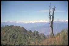
Bhutan and Its Natural Beauties


Bhutan is a land of picturesque landscape and rich history. Snow-capped mountains and bubbling streams can be seen any time of the year. Lower hills, carpeted by verdant land, are very pretty to watch. Bhutan's cultural heritage peeks from the monuments. Bhutan has Buddhist way of life and signs of this lifestyle can be seen anywhere. Bhutan is a right place for those who want to pass their vacations in solitude. See various pictures of Bhutan here and have a glimpse of the land of the thundering dragon.

Author Detail
Name:: Hemlal Bhattarai
Gender:: Male
Occupation:: Asst. Lecturer in Engineering college.
Qualification:: Master Degree in Power and Energy System
Interest::: Get myself lost in deepest core of nature beauty and cherish what actually the charm of nature.
Gender:: Male
Occupation:: Asst. Lecturer in Engineering college.
Qualification:: Master Degree in Power and Energy System
Interest::: Get myself lost in deepest core of nature beauty and cherish what actually the charm of nature.
Subscribe to:
Posts (Atom)